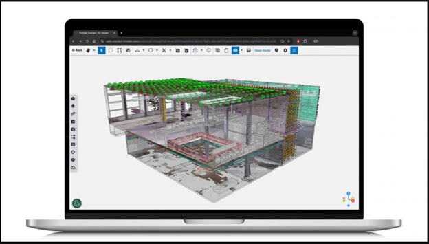
Trimble service to help firms make BIM models and digital twins of their projects.
Since announcing a partnership with Microsoft in October 2021, Trimble has steadily stayed on the path with its vision to assist the agriculture, construction and transportation industries on their digital transformation journeys. The company recently added another way to promote collaboration and streamline data management with its Reality Capture platform service.
Launched in September, the service offers a secure, cloud-based way to manage, share and visualize datasets from various technologies, including 3D laser scanning, uncrewed aerial vehicle (UAV) systems and mobile mapping. The web-based platform offers users an intuitive method for managing point clouds and 360-degree imagery with design data.
“This new service applies cloud technology in a new way for large data packages, allowing users to scale performance and maximize data value significantly,” said Boris Skopljak, Trimble vice president of geospatial. “Anyone can now benefit from accessing complicated reality capture data through a simple web interface, making it easier than ever to leverage geospatial information to drive better outcomes at every step of the design-build-operate lifecycle. With this launch, we are a step closer to realizing living digital twins and artificial intelligence applications at scale.”
The new platform is an extension of Trimble Connect, which is a tool for open collaboration that enables a single source of data for in-house and third parties. It elevates the ability for a connected workflow between the digital and physical worlds while making it easier to maximize the usage of reality-capture data.
“Utilizing the power and multilayered, built-in security controls of Microsoft Azure in combination with Trimble’s reality capture capabilities transforms scanning workflows to reduce point cloud analysis time from hours to minutes,” said Wangui McKelvey, general manager of Azure data analytics at Microsoft. “Enabling datasets of virtually any size to be easily shared and analyzed across teams means better, safer and more efficient output both on the job site and in the office.”
Designed for industries that rely on geospatial data, the Trimble Reality Capture service assists users in accessing datasets, whether using Trimble’s terrestrial laser scanners or third-party hardware. The data can then be used seamlessly alongside any 2D or 3D data.
The platform is integrated with Microsoft Azure Data Lake Storage and Azure Synapse Analytics. Whether in the field or off-site, key stakeholders can review, search, download, make model comparisons and analyze the data to make better-informed decisions and increase efficiency from a centralized, single source of truth. According to Microsoft’s Wangui McKelvey, general manager of Azure data analytics, integrating Trimble’s reality capture capabilities with Microsoft Azure reduces point cloud analysis times from hours to minutes.
Thanks to Trimble’s focus on connected solutions, reality capture data can be used with any of the company’s solutions—SketchUp 3D modeling tool, Trimble ProjectSight construction management software, Tekla structural BIM software—and third-party system integrators. Along with seamless integration, the Reality Capture platform service has a user-friendly interface, making it easy for contributors to manage data without extensive training better.
The Trimble Reality Capture platform service is offered as a subscription service through Trimble Geospatial distribution partners.