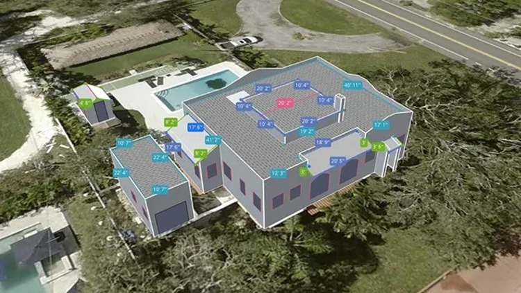
ROCHESTER, NY, Mar 4, 2026 – Eagleview has launched 3D property intelligence in Eagleview One, adding measurements for walls, windows, and doors across residential and commercial properties. The technology delivers 98.77 percent accuracy using high-resolution ortho and oblique imagery. The data can reduce or eliminate site visits by allowing users to review building dimensions remotely. Eagleview said the capability helps customers evaluate residential and commercial property data as they prepare for jobs.
“Today, we’ve dramatically improved one of the most time-consuming parts of work faced by industry professionals: the site visit,” said Piers Dormeyer, CEO of Eagleview. “Now, Eagleview One’s 3D models offer virtually all measurements and penetrations needed by both residential and commercial professionals in an interactive and intuitive user interface including the ability to isolate elements of the structure for analysis and part vs. whole report generation.”
Eagleview One enables virtual collaboration across residential and commercial property workflows. Users can review roof, wall, and door measurements in a standardized format from computers, tablets, or smartphones. This capability can reduce site visits and support faster project decisions with predictable costs.
The Eagleview One interface allows customers to access only the property data required for specific tasks. The platform supports multiple workflows from a single data source without increasing pricing. The service operates under a subscription model that offers predictable costs and access to platform updates.
“We’re giving customers a continuously usable, interactive digital representation of the property that replaces fragmented data, manual workflows, unnecessary site visits, and outdated records with real intelligence they can act on immediately for their routine and complex projects,” said Tripp Cox, chief product & technology officer of Eagleview.
The platform shares data and delivers tools for property data analysis. They can trust in Eagleview’s:
- Ultra high-resolution imagery
- Measurement quality which includes 98.77% accuracy
- Both ortho and oblique imagery from an authority in residential and commercial property image capture
- Technology forward and friendly tools like the ability to generate custom data sets
Eagleview One is used across multiple industries, with customers applying the technology in their workflows:
- Construction & Remodeling – Eagleview One supports faster bid cycles by reducing or eliminating the need for site visits. Teams can perform exterior material takeoffs remotely. The capability helps reduce delays, labor costs, and project risk.
- Insurance & Risk Management- Eagleview One supports faster underwriting and accurate property assessments using remotely captured property data. The platform allows insurers to review property information without physical inspections.
- Government & Public Sector – Eagleview One supports property assessment, permitting workflows, and remote property analysis using aerial imagery data. The platform can reduce field visits and provide consistent property measurements.
- Energy, Sustainability & Infrastructure – Eagleview One supports envelope analysis, retrofit planning, resilience modeling, and climate adaptation planning.
- Smart Cities & AI Innovation – Eagleview One provides property data used for predictive maintenance, valuation modeling, risk analysis, and AI systems.
The launch expands Eagleview’s property intelligence platform used in business applications and integrations across the built environment.
“This platform doesn’t just change how properties measurements are delivered,” added Cox. “It ensures our customers receive superior value and results from the aerial insights Eagleview generates so they can make better decisions.”
Source: Eagleview
About Eagleview

EagleView, founded in 2008 and headquartered in Bothell, WA, provides aerial imagery, geospatial data analytics and GIS mapping solutions. The company applies machine learning to high-resolution aerial imagery to generate actionable insights for industries including construction, insurance, solar, utilities and government. Its proprietary image library covers more than 98 percent of U.S. properties, supported by over 300 patents and more than 9.5 million linear miles of flight data processed annually. EagleView operates in the United States, with offices in Bothell and Rochester, NY. The company employs between 1,300 and 1,500 people and generates estimated annual revenue between $320 million and $750 million. Its services help organizations improve planning, streamline operations and make decisions based on property and infrastructure data.