

Researchers at the Chinese Academy of Sciences have developed two methods that improve 3D scene reconstruction and robot navigation. The technologies address challenges in autonomous systems, including changing lighting conditions, complex environments, and inaccurate positioning, tells Tech Xplore.
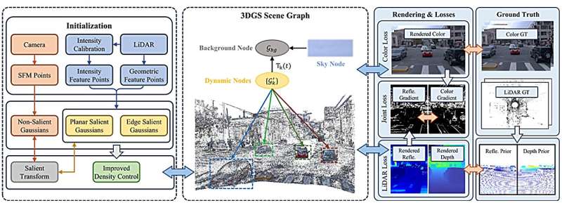
Led by Professor Zhu Hui at the Hefei Institutes of Physical Science, the research introduces LiDAR-Reflectance-Guided Salient Gaussian Splatting (LR-SGS) and Structure-Enhanced Multi-Meta Gaussian Distribution-Guided Visual SLAM (MMD-SLAM), two approaches designed to help robots create more accurate digital representations of their surroundings.
LR-SGS combines LiDAR measurements with camera images to reconstruct detailed 3D driving environments. By incorporating LiDAR intensity information, the method captures environmental details under varying lighting conditions, including nighttime scenarios. It also identifies important structural features while eliminating redundant information, improving reconstruction accuracy and computational efficiency.
Tests using datasets such as Waymo demonstrated improvements in reconstruction quality and training efficiency while maintaining compact 3D representations. These reconstructed environments are editable, allowing researchers to develop realistic virtual driving scenarios for autonomous vehicle simulation and testing.
The second method, MMD-SLAM, focuses on simultaneous localization and mapping. It uses geometric features, including points, lines, and planes, to improve robot positioning and environmental mapping.
By integrating these features, MMD-SLAM generates more consistent 3D point cloud maps and enhances localization accuracy, particularly in structured environments such as buildings. Experimental results demonstrated improved tracking and mapping performance without compromising real-time processing efficiency.
Both studies were accepted for presentation at the 2026 IEEE International Conference on Robotics and Automation. The LR-SGS research was also selected as a finalist for the Best Paper Award in robot perception, among more than 5,000 submissions.
Together, these developments could improve robotic perception, autonomous navigation, and simulation capabilities, supporting more reliable intelligent systems operating in complex real-world environments.
