

Researchers led by Seoul National University have developed an AI-based framework that can rapidly estimate city-scale structural damage even when satellite images are partly obscured by clouds, smoke, precipitation, or shadows. The approach combines structural engineering knowledge, satellite imagery, open data, and statistical techniques to support faster assessments after disasters, tells Tech Xplore.
Incomplete satellite imagery presents a major challenge during emergency response. Existing AI damage-assessment systems can also require extensive training data and computational resources, limiting their usefulness immediately after an event. The researchers address these problems through Scientific AI, which incorporates knowledge of physical and engineering processes into AI analysis rather than relying entirely on learned patterns.
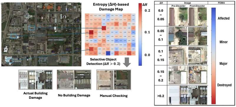
The framework compares satellite images captured before and after a disaster and supplements them with publicly available information. It uses image entropy, a measure of disorder or irregularity within an image, to quantify changes in buildings and their surroundings. These changes provide indicators of potential structural damage.
When imagery is incomplete, a statistical imputation technique reconstructs missing information using patterns and similarities in the available data. Unlike methods that discard incomplete observations or replace missing values with averages, this approach attempts to recover information statistically. It also eliminates the need to assemble large new data sets and retrain an AI model for each disaster.
The researchers validated the method using damage from a major typhoon. Even when clouds obscured more than 50% of satellite imagery, the framework estimated damage to urban buildings beneath the covered areas with less than 5% error. Tests involving major wildfire damage demonstrated its potential for other disaster types.
Rapid damage estimates could help emergency teams prioritize rescue operations, safety inspections, and recovery resources. Longer-term applications could include disaster planning and infrastructure management. The researchers also see possibilities in evaluating aging structures, machinery, ships, and aircraft, demonstrating a broader role for Scientific AI when engineering decisions must be made from incomplete visual data.
