

The twin earthquakes that struck northern Venezuela on June 24, 2026, not only caused widespread destruction but also permanently reshaped the Earth’s crust. The Wired article (full article available to subscribers) explains how scientists used radar-equipped satellites from the European Space Agency’s Copernicus program to measure these changes with remarkable precision, demonstrating the growing role of space technology in disaster assessment and response.
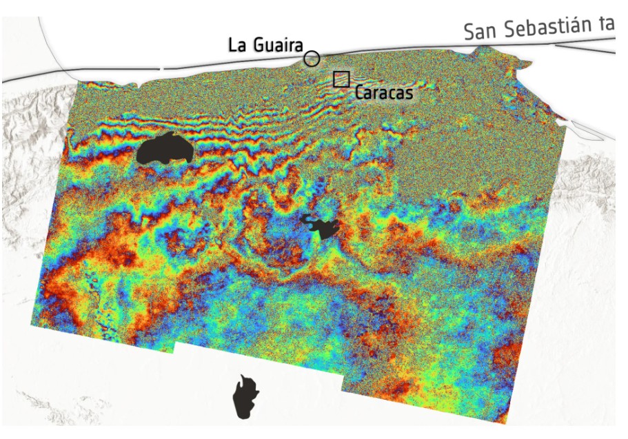
Unlike traditional optical satellites that capture photographs, the Sentinel-1 satellites use synthetic aperture radar to emit microwave signals toward Earth and measure the time it takes for those signals to return. By comparing radar observations collected before the earthquakes on June 18 with data gathered immediately afterward on June 25, researchers produced an interferogram, a detailed map that highlights even tiny shifts in the Earth’s surface that would otherwise remain invisible.
The resulting image displays a series of repeating colored bands across northern Venezuela. Each complete sequence of colors represents a fixed change in the distance between the satellite and the ground. Areas with more color cycles indicate greater cumulative deformation. The most significant changes appeared along the San Sebastián fault system, where the earthquakes originated. Scientists estimate that the ground shifted by approximately 30 centimeters, although the interferogram cannot determine whether the movement was upward, downward, sideways, or a combination of all three. Additional satellite observations and field surveys will be needed to fully characterize the displacement.
Beyond advancing geological research, the satellite data are playing an important role in humanitarian response. International space agencies are sharing imagery and analytical products with emergency management teams to help identify heavily affected areas, prioritize rescue operations, and assess damage to infrastructure. NASA has also activated its Disaster Response Coordination System to support recovery efforts with complementary satellite analyses.
The article illustrates how modern Earth observation satellites have evolved into indispensable scientific and emergency management tools. By combining radar imaging with advanced data processing, engineers and geoscientists can rapidly measure crustal deformation after major earthquakes, improving both the understanding of tectonic processes and the coordination of disaster relief when every hour matters.
