Mexico City has been sinking for more than a century, but new satellite observations are revealing the scale and speed of the crisis with unprecedented precision. A recent report from Wired.com (full article available to subscribers) explains how NASA’s NISAR satellite mission has mapped the uneven collapse of the Mexican capital, exposing areas where the ground is dropping by more than two centimeters per month.
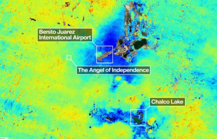
The NISAR satellite, developed jointly by NASA and the Indian Space Research Organization, uses advanced synthetic aperture radar to detect minute changes in Earth’s surface. Unlike optical imaging systems, radar can observe land movement through clouds and darkness, allowing scientists to monitor geological shifts continuously. Early measurements collected between October 2025 and January 2026 captured dramatic evidence of subsidence across the metropolitan region.
The problem is deeply tied to Mexico City’s geography and growth. Much of the city was built atop the ancient lakebed of Lake Texcoco, where soft clay soils compress as groundwater is extracted from underground aquifers. Decades of pumping water to sustain a population of more than 20 million people have accelerated the collapse. Urban expansion and the enormous weight of modern infrastructure have added further pressure to the unstable ground beneath the city.
The effects are already visible throughout the city. Roads crack, pipelines rupture, buildings tilt, and parts of the metro system face structural strain. Land subsidence is especially dangerous because it occurs unevenly, creating “differential subsidence” that destabilizes foundations and transportation systems. Critical infrastructure, including Benito Juárez International Airport, lies within heavily affected zones.
The article presents NISAR not simply as a scientific achievement but as a warning system. By tracking ground deformation in near real time, the satellite could help urban planners, engineers, and policymakers better understand where infrastructure risks are escalating. Yet the technology also highlights a difficult reality: the sinking is continuing because the city remains dependent on the very groundwater extraction driving the collapse.